Eurovelo 13: Cycling the Iron Curtain from Harz to Bratislava
Eurovelo 13 (EV13) is not a cycle route for those who want to get from A to B as fast as possible. Just like life, it is more of a pointless, meandering ride that often turns back on itself only to climb some huge hill. It is the newest and wildest of the European cycle routes which traverses through Europe’s ‘Nature Corridor’: the remnant of four decades of restricted access to the borders between the East and West during the Cold War. The route goes from the Barents Sea in the Arctic Circle to the Black Sea, covering over 14,000km. On a bicycle, the journey is give or take six months. Having only limited time to cycle tour on EV13, my friend Bill and I cycled from Berlin to Bratislava.

West Germany-East Germany (~650km; 14 days)
It took us five days from Berlin on Eurovelo 2 (another European route) to reach EV13 in the small town of Ilsenburg just north of the Harz national park. The climb up the forested, granitic hills of the reserve are long and strenuous but highly rewarding. The views from Northern Germany’s highest peak Brocken are striking on a clear day. Wild camping is not advisable along this stretch as there are plenty of patrolling German park rangers. Instead, we stayed at Harz Camping at Schierker Star. The campsite is run by a Finnish couple and blends in nicely with the forest. It has a sauna, cosmopolitan young campers (which is a rare find in most EV13 campsites) and psychedelic 70s music playing from the in-built speakers in the showers.

Cycling southwards out of the national park, the route took us through the typical Saxonian-Thuringian scenery of endless forested hills, large agricultural fields and middle-of-nowhere villages in which contrary to common belief, very few people speak English. Eastern German schools used to teach Russian in schools up until the 1990s while English was not encouraged. Long stretches of soviet patrol roads can be seen throughout the whole route but more often so in this area. These were for the most part cheaply constructed using narrow, loosely-joined, soviet-style concrete blocks which proved a nightmare to cycle on. Also, the Grenzlandmuseum Eichsfeld near Duderstadt has some of the best kept border infrastructure we saw. The ex-border-crossing-turned-museum showcased the brutality of soviet border infrastructure as well as local life during the Cold War.

A short distance past Duderstadt, the EV13 flanks the Werra River and follows this natural border upstream for over 100 miles on a typically-smooth German cycle path. The tributaries flowing into the river from the east often display the Cold War-era river fences and flood lights that were used by border patrol guards to stop people swimming into the West. This area is also famous for its mammoth potash mine tailing dumps (now some of the highest hills in the area). Bill and I thought these were a good example of how the Germans have struck a fair balance between maintaining extractive industries operational whilst protecting the environment at the same time (perhaps not visual pollution…). We then made a stop at the Alpha Point museum: A Cold War era American base overlooking the Fulda Gap, the passage across the Iron Curtain deemed most likely for a Warsaw-pact invasion into the West. A short stay in a nearby rural camp site coincided with a local kermesse which gave us some insight into deepest rural Germany. The close-knit community we encountered welcomed us to their own version of country music, circle dancing and endless supply of local beer and spirits. On the downside, they did not seem to be too fond of migrants and obesity was clearly a big problem.

The old Iron Curtain then peels-off the Werra and continues southwards and then eastwards along the Bavaria-Thuringia border. Rural Bavaria felt no different to the previous regions as the scenery remained similar, but we did feel a change in the cultural landscape. Bavarians seemed very keen on their local beer festivals, where villagers dress up in their full Bavarian kit and get blind drunk on good beer. After a particularly long day on the bikes in bad weather, we desperately sought shelter near the slate-roof town of Lehesten, a town that used to host V2-rocket liquid oxygen plants in its slate mines during WW2. Feeling our urge for food and shelter, a pair of locals kindly directed us to a quaint, community-run wooden wagon-turned-shelter known locally as Alte Mühle Wasserrad. It lies hidden in the forests a couple of miles west of town, and there are no signs pointing to its existence. This shelter is normally equipped with beer, food and a donations box.

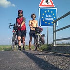
Czech Republic-Germany (~450km; 10 days)
A few days of Bavarian cycling was enough to reach the Czech-German border, which takes on the hilliest terrain of the EV13. Since this is still an international, ethno-cultural border, it is much sharper than the former border between East and West Germany. As an Anglo-Saxon, Czech is an incomprehensible Slavic language. We found that prostitution is rife near the main border roads and towns (especially in the town of Aš), and that road quality decreases sharply (to be fair, when it comes to road quality, any country struggles to compete against the Germans). On the other hand, Euros are widely accepted despite not being the official Czech currency, most things are half price compared to Germany, and generally our experience was that the Czech were friendlier and more community-oriented. Also, unlike Germany, we found that young people in their 20s and 30s still seem to populate smaller towns. We thought Cheb is a very nice town on the route with a well-kept historical center and some nice places to eat Goulash and drink pivos. Other nice towns we visited include Tachov and Domažlice, where many breweries can be found nearby. Most of the cycling on this segment is along the Czech side of the border going through the pine forests of the Český Les and Šumava national parks. Czech Pilsens won us over and I found Birrell to be the nicest non-alcoholic pivo I have ever tried.

Czech Republic-Austria (~480km, 7 days)
Approaching the Austro-Czech border, EV13 follows the Schwarzenbergkanal, an 18th century logging canal built to ‘float’ timber down the canal for use in Vienna. As the border meanders eastwards, the terrain gradually flattens past the lakes in Trebonsko and into the South Moravian plains. There lies a steep gorge with a castle in Podyjí national park, the historical town of Znojimo (also a good place for re-supplying), the largest garden in the Czech Republic in Lednice and some of the best-known vineyards in central Europe. Thanks to the latter, there is also plenty of Burčák (Federweisser in German) in September: a fizzy, continuously fermenting alcoholic grape juice being sold by local farmers on roadsides).

Austria-Slovakia (~90km; 2 days)
The final stretch of EV13 leaves the Czech Republic and goes along the Austro-Slovakian border into our final stop in Bratislava. This part is relatively easy in terms of terrain as it follows the Morava River downstream through its surrounding flat plains. Being part of Czechoslovakia until the Velvet Divorce in 1993, the culture, language and food in Slovakia are very similar to that of the Czech Republic (except that the Euro is the official currency in Slovakia). Devin Castle is a must stop on the way to Bratislava as it has some amazing views of the plains near Vienna, the Austrian Alps on a clear day and the mighty Danube river. Vienna is less than 50 miles away following the Danube on EV6 (one of the best-known European cycle itineraries). Bratislava is, for a capital city, very small with a population of less than 500,000 people, but with enough sights, free walking tours, bars and restaurants to keep any visitor busy for a few days.

Summary and Remarks
Overall, it took us 33 days to cycle this ~1700km arbitrary section of EV13 at a leisurely pace, taking it day-by-day, and carrying all of our equipment (camping kit, bike repair kit, clothes, food and a few extra luxuries). We recommend keeping track of the days as most things shut on Sunday (including supermarkets and bicycle shops). EV13 .gpx track files are available online but are tricky to find, and also differ slightly from one another. The Eurovelo 13 App on the phone is still in its early stages as of September 2018, but is useful in finding interesting sights near the route.

We slept wherever we could: In campsites, wildcamping, with couch surfing hosts, warmshowers.org hosts, in shelters and in cheap accommodation when available. Wild camping is technically not allowed in the aforementioned countries but quite easy with some common sense (i.e. tents erected at dusk, taken down by morning and well hidden from view). Since all the countries visited are currently within the Schengen Area there is free movement and rare patrolling across the borders. It is worth keeping in mind that Lyme-disease-bearing ticks are common in the forests, for which tick-specific tweezers, anti-septic cream and regular tick-checks can come in useful (i.e. I got bitten by a dozen ticks during the trip).
What makes Eurovelo 13 stand out?
Scenic, historically-rich, international long-distance cycling itineraries like EV13 are commonplace in Europe and around the world. For us, what set it apart was how it skillfully routed us away from most popular destinations by zigzagging up and down forested hills and in and out of marginal towns. We inevitably stumbled upon the forgotten realities left behind by modern pick-and-choose tourism. After all, touring in what was no-man’s-land for four decades was never going to be the popular choice.